Construction productivity — Research focus
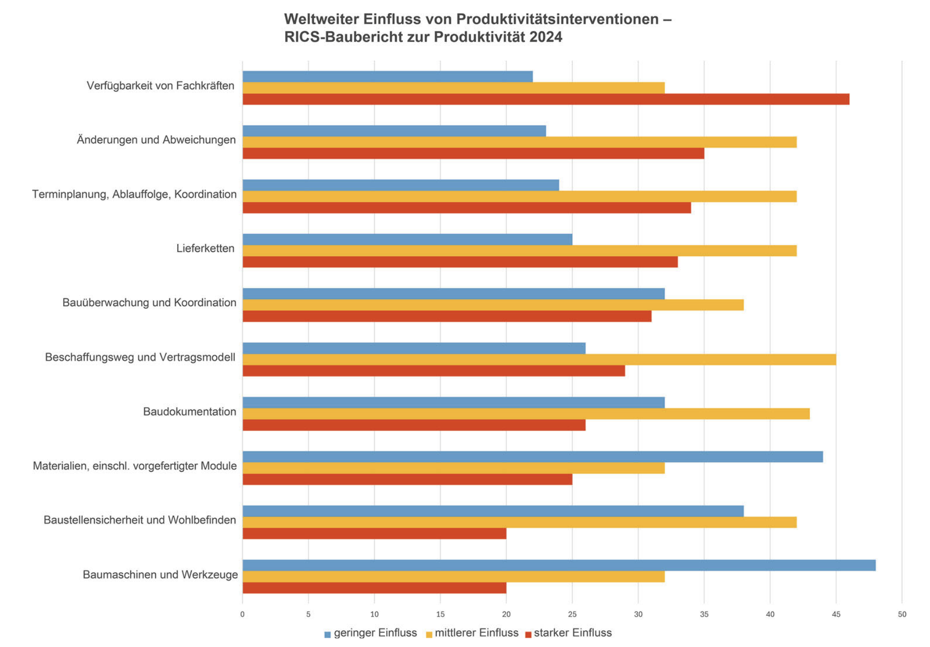
Construction productivity in Germany and in most industrialised economies has stagnated for decades, while manufacturing, logistics and agriculture have multiplied their efficiency over the same period. This productivity gap is not a measurement artefact; it reflects structural properties of the sector: fragmented value chains, project-based one-off production without repeatable learning effects, the absence of standardised output units, and a weak data base along the execution layer. To this comes a cultural pattern in which human labour is regarded as the dominant productivity driver, while the long-term potential of technological interventions is systematically underestimated — a perception documented in recent industry surveys such as the RICS Construction Productivity Report (see Fig. 1).
My research focus addresses exactly this gap. It combines a multi-level view of productivity — from the macroeconomic level of the industry through firms and projects down to the individual process step on site — with the methods of digital and AI-driven process analysis. The aim is a productivity steering approach that does not collapse into a single aggregated indicator but makes cause and effect traceable and comparable across all control levels. The methodological and didactic foundation of this work is the German-language reference book Digitale und KI-gestützte Produktivitätsanalyse im Bauwesen — Der smarte Einstieg für KMU (Bühler, Nübel, Hollenbach, Köhler, Jelinek; Springer Vieweg, 2026; DOI 10.1007/978-3-658-49587-9 link). It addresses practitioners in mid-sized firms and students of construction economics, construction management and construction informatics in equal measure.
Multi-level framework
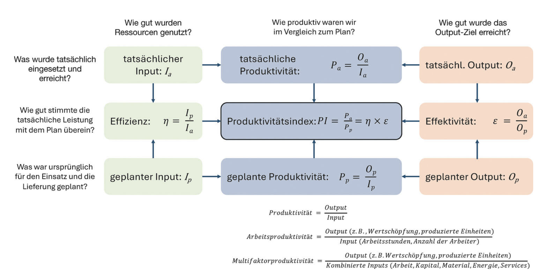
Construction productivity cannot be captured by a single indicator. Classical aggregates such as labour productivity or total factor productivity (TFP) allow macroeconomic comparisons but fall short the moment concrete projects or processes need to be steered. Construction has no uniform output unit: square metres, cubic metres and linear metres measure different things, and contract forms, site conditions and trade structures add further heterogeneity.
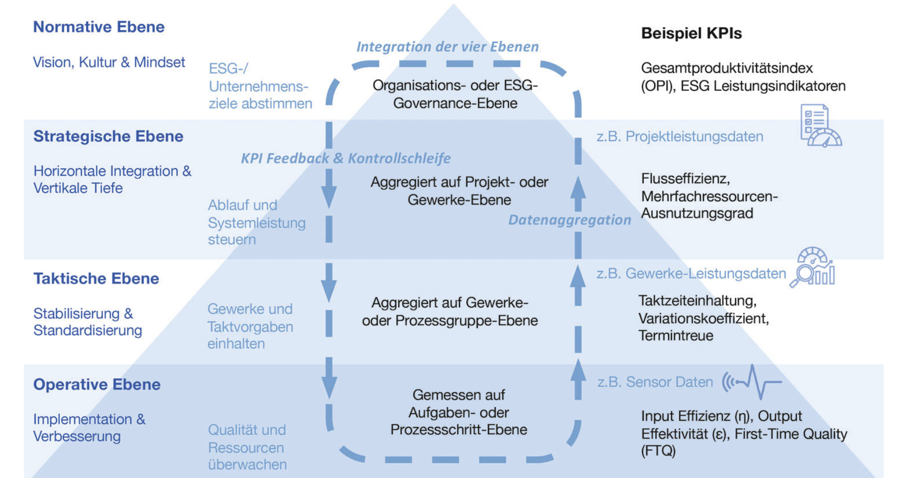
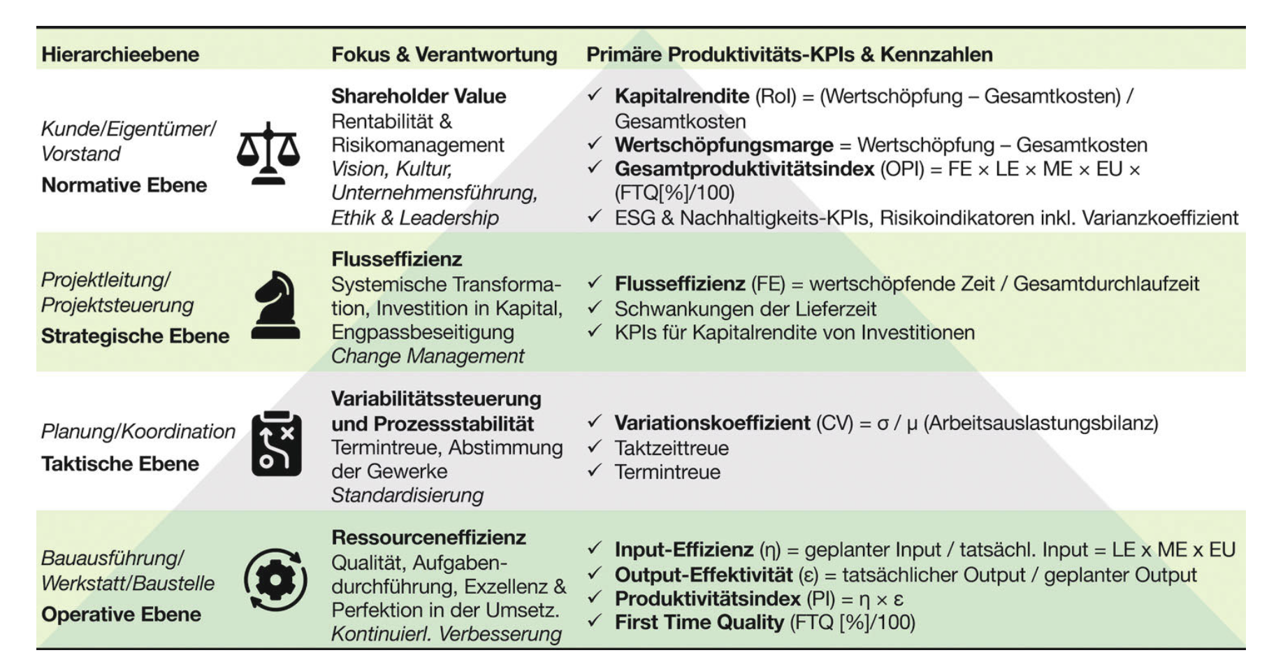
I therefore work with a hierarchical framework that describes productivity on four consistently linked levels: an operational level, which captures individual process steps on site as repeatable value-stream elements (placing a reinforcement cage, installing formwork, pouring concrete); a tactical level, which controls sequencing and hand-overs between trades within a construction section or floor; a strategic level, which aggregates performance across projects and portfolios for benchmarking; and a normative level, which links operational figures to corporate goals, sustainability and societal impact (see Fig. 2 and Fig. 3).
The steering logic differs by level. The operational level is dominated by efficiency in terms of resource productivity, low waste and short tact times — "doing things right". The strategic and normative levels emphasise effectiveness — "doing the right things". The tactical level forms the bridge: it secures adaptive coordination and the management of interfaces between trades. The methodological message of the model is straightforward: only when productivity is defined consistently across all levels using the same ontology can causal links be demonstrated — for example between a tact disturbance on site and a margin shift at firm level. A detailed derivation of the framework, together with its flow-based system logic, can be found in chapter 5 of the reference book.
Digital and AI-driven transformation
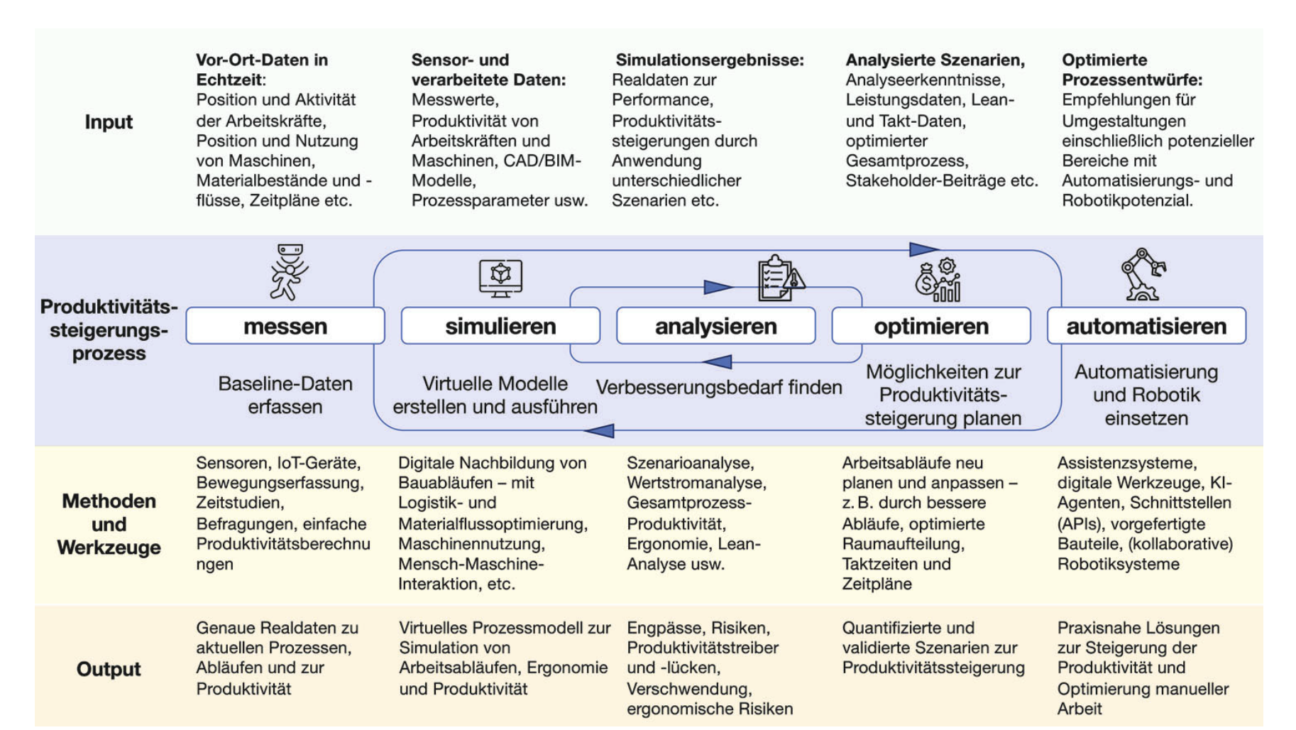
Digitalisation and artificial intelligence change the way construction productivity can be measured and steered — not primarily through new tools on site, but through a continuous data chain from sensors to decisions (see Fig. 4). In the book we describe this transformation along three conceptual stages established by Fraunhofer IESE: the digital model as a static representation, the digital shadow, which continuously observes the real process, and the digital twin, which only through a bidirectional coupling between sensor and control system enables active process regulation.
A second ordering principle concerns human–AI interaction. The book draws on the seven-stage spectrum of human–AI cooperation, which ranges from purely human decisions (human-only decision) through increasingly coupled configurations (human-in-the-loop, human-on-the-loop, human-in-command) to largely autonomous agentic systems that dispose tasks independently and only escalate when required. Agentic AI systems typically sit in the middle of this scale: they act independently but remain controllable through defined intervention points, feedback mechanisms and governance structures. For construction practice this means that neither full automation nor full human control is the goal; rather, a task-specific distribution of responsibility between people and systems — depending on the risk, reversibility and data availability of the respective process step.
Methodologically we complement these spectra with standards for process modelling — such as BPMN and VDI 5600 — and with dynamic value stream analyses that link lean methods to live data from IoT, MES and ERP.
This transformation has a direct teaching dimension. The new study programme Master of Applied AI Transformation Management (MAI), starting in summer semester 2027 at HTWG Konstanz, addresses precisely the gap between civil engineering, production systems and applied AI. It translates the principles developed in the book into a part-time qualification for engineers who will be responsible for this transformation in mid-sized companies.
Methods and tools
The methodological toolkit of this research focus combines established procedures from industrial production with construction-specific adaptations. Five building blocks form the core, systematically introduced in chapter 4 of the reference book (see Fig. 5 and Fig. 6):
- Discrete-event simulation (DES) as the main method for modelling flow efficiency, bottlenecks and waiting times in construction sequences. DES allows tact decisions, crew deployment and logistics concepts to be tested in a virtual process environment before execution.
- Value stream mapping (VSM) and its dynamic variant Dynamic Value Stream Mapping, extended by real-time data from sensors and ERP. VSM bridges the methodological gap between accounting and on-site operations and makes value-adding, supporting and non-value-adding activities distinguishable.
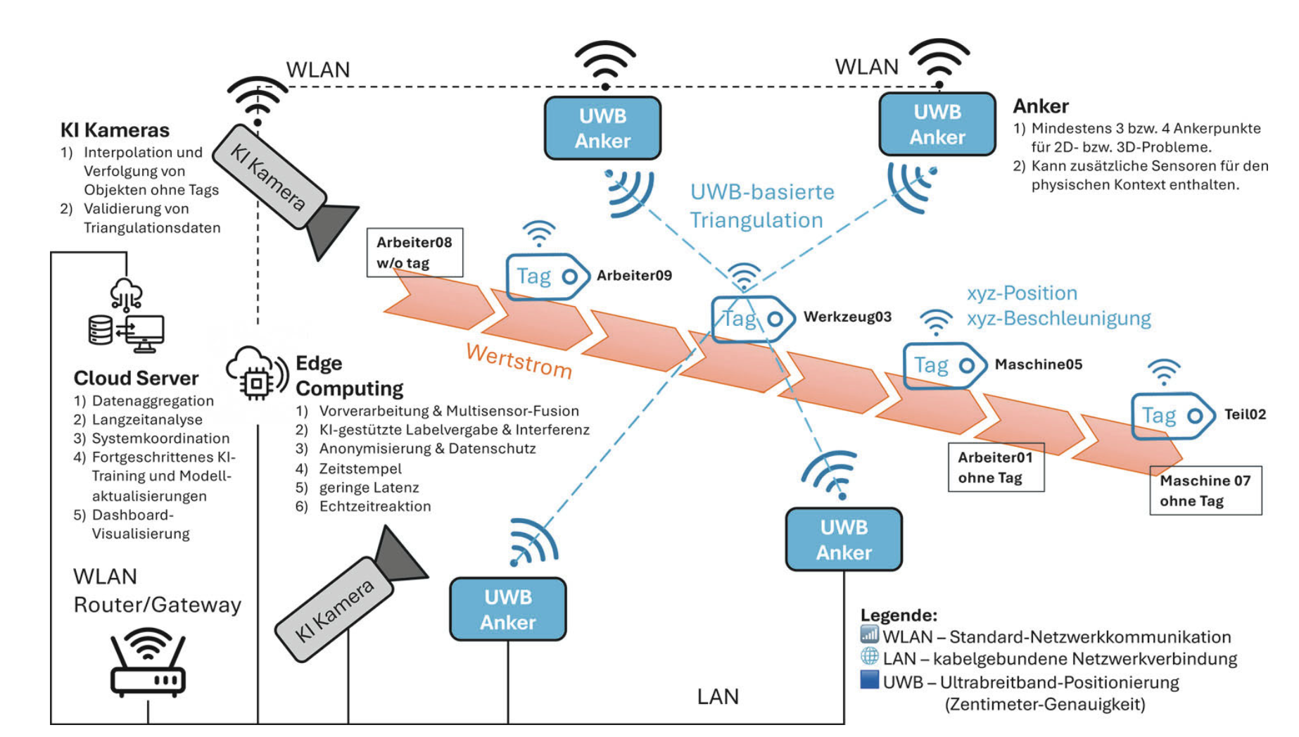
- Real-time location systems (RTLS) based on ultra-wideband anchors and tags, complemented by AI-driven cameras for capturing untagged objects. The combination produces a context-sensitive, data-protection-compliant process twin of the site.
- Data fusion across BIM, IoT sensors and ERP or project management systems through open standards such as MQTT, OPC UA and IFC. The semantic linkage of these sources is the precondition for turning heterogeneous individual signals into a consistent steering picture.
- Edge/cloud architectures with local pre-processing where the action happens and centralised aggregation, model training and visualisation. This separation enables reactive decisions in real time and, in parallel, strategic analysis across project boundaries.
These building blocks are not designed as a monolithic end-to-end solution but as a modular architecture that can be adapted to the maturity of the individual firm and project. Operational testing takes place, among others, in the research project Walz 4.0, which connects craft knowledge and digital human–machine interaction in a productivity-related context and thereby investigates the bridge between tacit experience and data-based steering.
Implementation in SMEs — the smart entry point
The research focus and the reference book explicitly target mid-sized construction companies. Large budgets, in-house IT departments and multi-year transformation programmes are the exception in this segment. In chapter 7 of the book we therefore develop a pragmatic seven-step sequence for the smart entry into digital and AI-driven productivity analysis:
- Identifying pain points, bottlenecks and potentials: structured employee interviews, value-stream walks, time studies and movement diagrams make friction losses visible and prioritise the places where digitalisation has the strongest leverage.
- Defining concrete goals and value propositions: SMART objectives in the categories time, cost, quality, sustainability and employee relief — linked to an honest value proposition for the workforce.
- Selecting and assessing suitable technologies: systematic evaluation by maturity, fit with the existing infrastructure and ratio of efficiency gain to effort. A simple utility analysis replaces the large IT project.
- Piloting with quick-win character: lean pilots in a clearly delimited, non-critical process area — for instance a digital construction diary, mobile time-recording or AI-driven delivery-note recognition. Early successes build trust and connectivity for the next stage.
- Empowerment and participatory implementation: employees are involved early, digital champions are trained, and a constructive error culture is established. Digitalisation thus becomes a matter for the workforce, not for an abstract staff function.
- Measuring impact systematically: before-and-after comparison with consistent indicators on the operational, tactical and strategic levels. Only solid data make it possible to justify investments and prepare scaling.
- Preparing scaling, anchoring strategically and celebrating successes: successful pilots are transferred into a digital roadmap, anchored in corporate strategy and personnel development, and learning successes are made visible. Only at this stage do structural investments in platforms, interfaces and training pay off.
This logic breaks with the widespread pattern of treating digitalisation as an end-to-end large-scale project and replaces it with a modular, low-threshold sequence that allows SMEs to start with manageable risk and to build up learning curves. In parallel we rely on a participatory implementation supported by digital champions, a constructive error culture and the early involvement of the operational workforce — because the largest barrier to digital transformation in construction is rarely the technology, but its compatibility with grown work routines.
Textbook, teaching and theses
The reference book Digitale und KI-gestützte Produktivitätsanalyse im Bauwesen — Der smarte Einstieg für KMU (Bühler, Nübel, Hollenbach, Köhler, Jelinek; Springer Vieweg 2026; ISBN 978-3-658-49586-2 (print), 978-3-658-49587-9 (eBook); DOI link) forms the didactic foundation of this research focus. It is published as part of the series Bauwirtschaft und -management — Praktiken, Entwicklungen und Perspektiven (Springer Vieweg) and addresses practitioners as well as students of civil engineering and business-oriented construction programmes. The book emerged from interdisciplinary dialogues with craft enterprises, construction firms, architectural practices, IT developers and researchers, and is introduced by a foreword by Thomas Bauer.
In teaching at HTWG Konstanz this focus feeds primarily into the topic area Construction productivity and is linked with courses on lean management, digitalisation in construction, project control and general business administration. An overview is provided on the Teaching tab. The new study programme Master of Applied AI Transformation Management (MAI), starting in summer semester 2027, makes the principles developed in the book the foundation of a dedicated qualification.
Theses in the field of construction productivity are explicitly welcome — particularly on topics around digital value stream analysis, discrete-event simulation, human–AI cooperation on construction sites, Walz 4.0 and the circular economy. Topic proposals and advertised theses are documented on the Teaching tab. Independent ideas from practice — for instance from working-student positions or internships in mid-sized construction firms — are welcome, provided they connect to the methodological line of the multi-level framework and digital productivity analysis.